Identifier
GH2022_T_4
Type
Title
GH2022 trench 4
Description
Excavation trench located on the middle part of the bow extending for circa 1.2 meters along and 0.75 meters across the ships' centreline to expose the lower stempost element, thereby fixing the ship's spatial orientation and determining its length. Refilled with clean sand after 3D documentation.
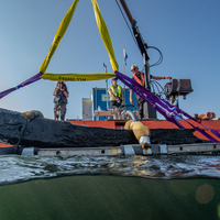
Investigation site
Investigation dates
August 30, 2022 – August 31, 2022
Investigation technique
en
dredge

Set 3DHop scene
Model measure unit
en
meter
Longitude shift
513000
Latitude shift
6222000
Spatial reference system (EPSG)
EPSG:3006
Date Created
January 2, 2022
License
en
CC-BY 4.0


")
| Plane | Position | Flip |
| Show planes | Show edges |
Measured length
0.0
0.0
Coordinates (EPSG:3006)
[ 0 , 0 , 0 ]
[ 0 , 0 , 0 ]
Check All