-
Identifier
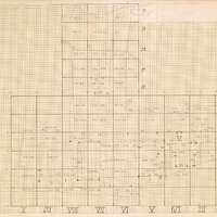
Trinitatis_excav_plan
3D model type
en
terrain
Title
Trinitatis excavation plan (3D model)
Description
The hand-drawn plan of the excavation conducted at the cemetery of Trinitatis by the Drotten Church.
Investigation campaign
Investigation site

Dataset acquired by
Model format
en
nxs
Model measure unit
en
meter
Dataset location
en
Lund University (Sweden)
Date Created
October 30, 2025
Rights Holder
en
Lund University (Sweden)
License
en
CC-BY 4.0
Other Media
Linked resources
| Trinitatis Trench 840 |


| Plane | Position | Flip |
| Show planes | Show edges |
Measured length
0.0
0.0
Coordinates
[ 0 , 0 , 0 ]
[ 0 , 0 , 0 ]
Trackball position