Identifier
Title
Context type
Context subtype
Description
Top Soil
Interpretation
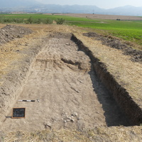
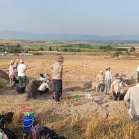
C600 corresponds to the top soil of the entire trench down to preserved in situ remains found at 40 cm to 60 cm depth. It was excavated from south to north using a 50 cm-wide toothed bucket, which left some scars on the surface.
The uppermost 20 cm consist of very loose topsoil made up of light brown clayish silt with small stones, disturbed by agricultural activities, plant roots, and animal burrows. This layer lies above the two burials F1 (skeleton C603) and F2 (skeleton C623), the enclosure C601, the adjacent layers C605, C604, and C620, as well as the stone deposit at the southern limit of the trench (C611, C615).
[Previous notes on paper recordings : At the south limit of the trench. it supposed to be the inside area of trench set C604 and the redish brown area which is apart from south limit consider to be the ditch set C601 but it seems like a wall after excavated. And there is a skeleton at the 10m far from south wall, which set C603(F1) The machine clean from north to south.]
Excavation date
Record creator
Excavation technique
Investigation area
Investigation site

Location in the investigation area
Length
Length measure unit
Width
Width measure unit
Thickness
Depth measure unit
Excavated amount
Truncated
Sediment type
Compaction
Contact area boundaries
Bottom boundary
Context color modifier
Context color
Grain size
Composition modifier
Composition
Record completeness status
Date Created
Date Modified
Rights Holder
License
Notes or comments
The planimetric dimensions correspond to those of the trench.
Linked resources
| TS Area 5 (H8) |
| TS2023 context 602 |
| TS2023 context 604 |
| TS2023 context 606 |
| TS2023 context 611 |
| TS2023 context 620 |
| TS2023 Feature 1 |
| TS2023 context 605 |


")
| Plane | Position | Flip |
| Show planes | Show edges |
0.0
[ 0 , 0 , 0 ]