Identifier
GH2022_Ship_Area1
Type
Title
GH2022 Ship area 1
Description
The shipwreck area in its entirety, with the location of the areas excavated in 2022 and the samples taken.

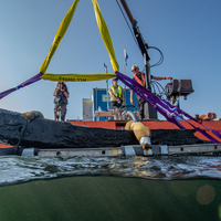
Investigation site
Gribshunden
Investigation dates
August 22, 2022 – September 2, 2022
Investigation technique
en
dredge
Model measure unit
en
meter
Longitude shift
513000
Latitude shift
6222000
Spatial reference system (EPSG)
EPSG:3006
Date Created
August 25, 2022
Rights Holder
LU
License
en
CC-BY 4.0
Linked resources
| GH2022 Sample 10 |
| Gribshunden Campaign 2022 |
| GH2022 context 3000 |


")
| Plane | Position | Flip |
| Show planes | Show edges |
Measured length
0.0
0.0
Coordinates (EPSG:3006)
[ 0 , 0 , 0 ]
[ 0 , 0 , 0 ]
Check All