-
Identifier
GH_GIS_data
Type
en
polygons
Title
GH GIS data
Description
GIS data from the investigation at the wrecksite of Gribshunden
Features represented
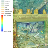

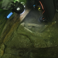
Investigation site

GIS data format
en
Geojson
Spatial Coverage
Wreck area
Dataset location
en
Lund University (Sweden)
Spatial reference system (SRS)
en
EPSG:4326
Date Created
November 7, 2025
Rights Holder
en
Lund University (Sweden)
License
en
CC-BY 4.0
Other Media
Linked resources
| Gribshunden Campaign 2019 |